ORDINANCE NO. 91684-0611
AN ORDINANCE AMENDING TITLE 10, CHAPTERS 4 AND 5
OF THE CITY CODE RELATING TO FLOODPLAIN MANAGEMENT
REGULATIONS IN THE CITY OF MUSCATINE, IOWA.
WHEREAS,
The Federal Emergency Management Agency (FEMA) has completed a
Flood Insurance Study and Flood Insurance Rate Map for Muscatine County, including the City
of Muscatine which become effective on July 18, 2011; and
WHEREAS,
In order for City of Muscatine residents and businesses to be able to
continue to participate in the National Flood Insurance Program, the City of Muscatine must by
July 18th adopt legally enforceable floodplain management regulations that are compliant with
Title 44 Code of Federal Regulations 60.3; and
WHEREAS,
The City of Muscatine in order to ensure that residents will continue to be
eligible to participate in the National Flood Insurance Program has prepared an ordinance to Title
10, Chapters 4 and 5 that will bring the City's floodplain management regulations into
compliance with Title 44 Code
of Federal Regulations 60.3; and
WHEREAS,
The City Council has conducted a public hearing concerning the following
amendments to Title 10, Chapters 4 and 5 of the City Code, floodplain management regulations;
NOW, THEREFORE BE IT ORDAINED BY THE CITY COUNCIL OF THE
CITY OF MUSCATINE, IOWA:
SECTION 1. The currently adopted versions of Title 10, Chapters 4 and 5 of the City
Code are here by deleted and Exhibit A as attached hereby to is adopted in lieu thereof.
SECTION 2.
If any section, provision or part of this ordinance shall be adjudged invalid
or unconstitutional, such adjudication shall not affect the validity of the ordinance as a whole or
any section, provision or part thereof not adjudged invalid or unconstitutional
SECTION 3. Any Ordinance or part thereof in conflict or inconsistent with the
provisions of this Ordinance is repealed.
SECTION 4. This ordinance shall be in effect from and after its final passage, approval
and publication as provided by law.
PASSED, APPROVED AND ADOPTED this 16th day of June, 2011.
3^ffiP
gg Mancfeager, City Administrator
First Reading: May 19, 2011
Second Reading: June 2, 2011
Final Reading: June 16, 2011
Publication: June 22» 20n
BY THE CITY COUNCIL OF THE
CITY OF MUSCATINE, IOWA
iihard W. O'Brien, Mayor
.
Title 10-Zoning
Chapter 4 - FP Flood Plain District
SECTIONS:
10-4-1 Intent and Purpose
10-4-2 District Boundaries
10-4-3 General Provisions
10-4-4 Permissive Uses
10-4-5 Conditional Uses
10-4-6 Height, Area, Parking Requirements
10-4-7 Flood Control Manual
10-4-8 Administration
10-4-9 Definitions
10-4-1 Intent and Purpose.
A. The Legislature of the State of Iowa has in Chapter 414, Code of Iowa, as amended,
delegated the power to cities to enact zoning regulations to secure safety from flood and
to promote health and the general welfare.
B. It is the purpose
of the Flood Plain District to apply special regulations to the use of
land in those areas of the City which are subject to predictable inundations at frequent
intervals and to assure that flood carrying capacity within the altered or relocated portion
of any watercourse is maintained. Such land use controls are necessary to qualify
property owners for flood insurance under the National Flood Insurance Act of 1968 (as
amended).
C. The regulations, while permitting reasonable economic and social use of such
properties, will help protect health, safety, and general welfare and reduce financial
burdens imposed on the community, governmental units, and its individuals caused by
frequent and periodic floods and the overflow of lands.
D. The standards required by this Chapter are considered reasonable for regulatory
purposes. This Chapter does not imply that areas outside the designated Floodplain
(Overlay) District areas will be free from flooding or flood damages. This Chapter shall
not create liability on the part of the City of Muscatine or any officer or employee thereof
for any flood damages that result from reliance on this Chapter or any administrative
decision lawfully made there under.
10-4-2 District Boundaries.
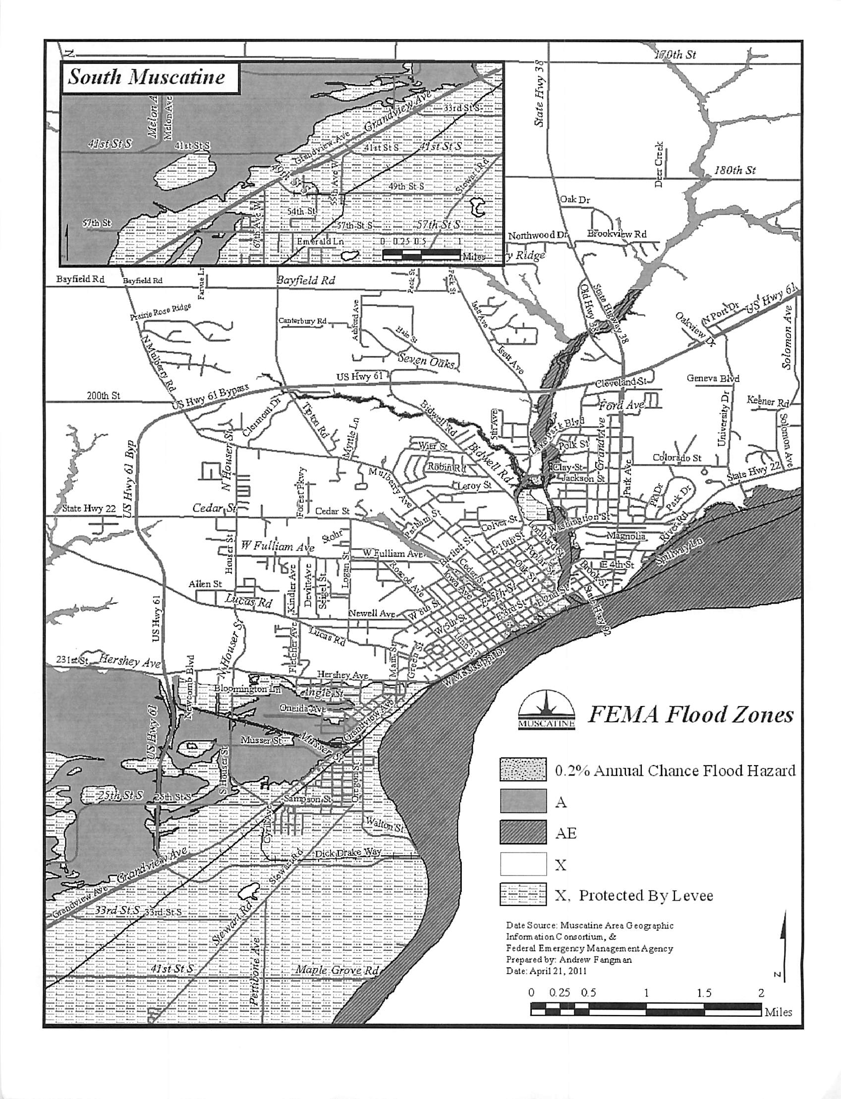
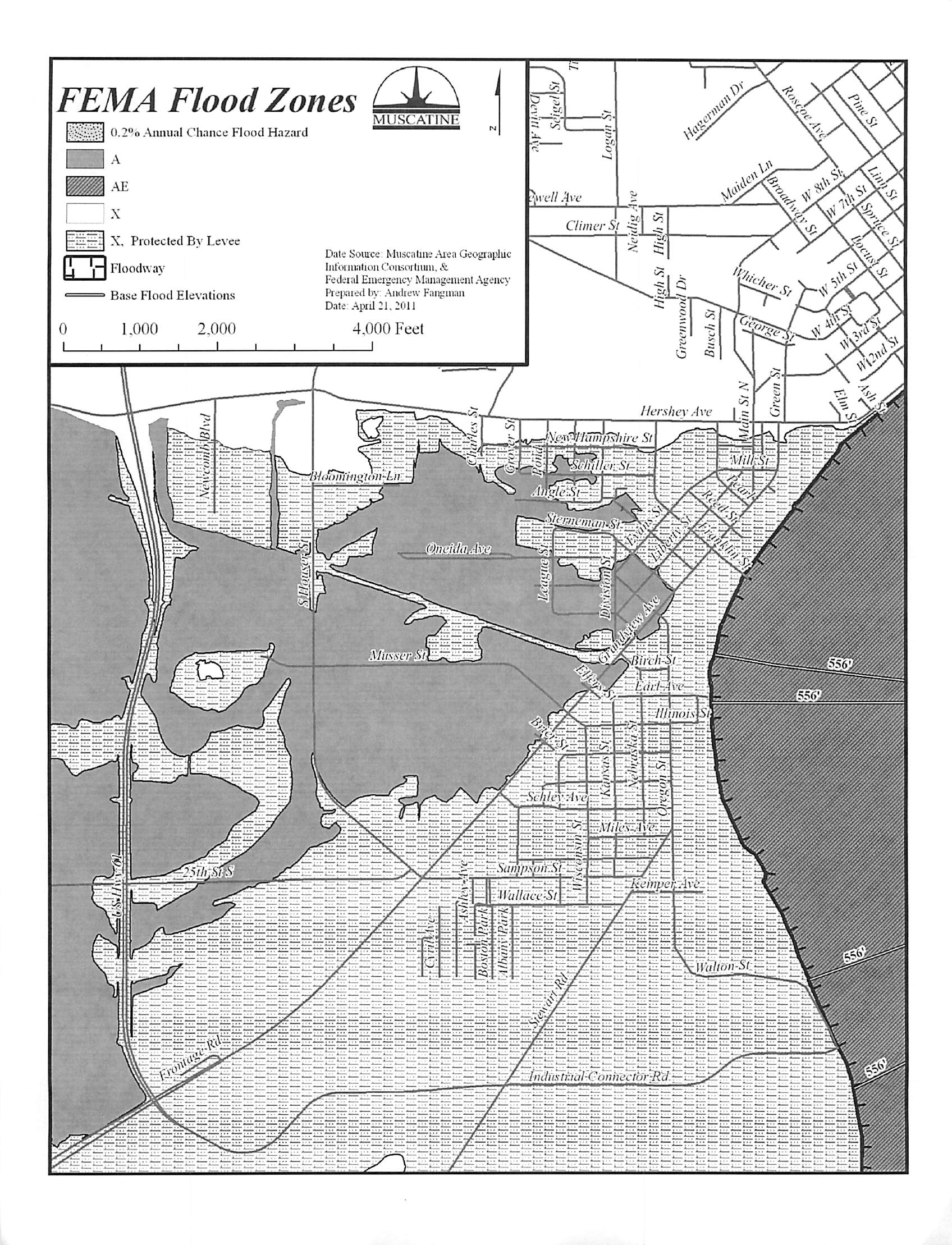
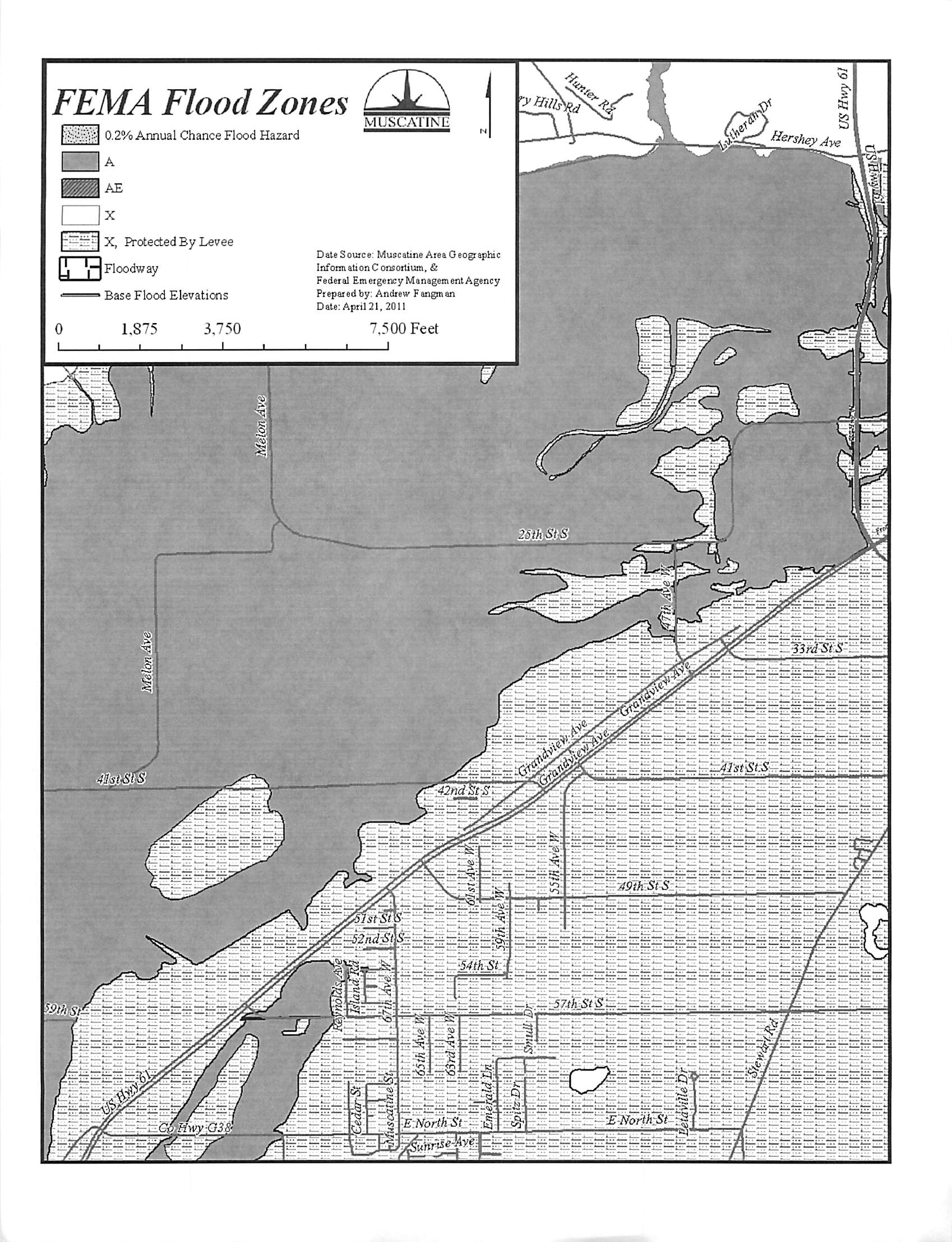
A. The boundaries of the Flood Plain District are hereby established as the areas
classified as "Zone AE or Zone A" on the Flood Insurance Rate Map (FIRM) for
Muscatine County and Incorporated Areas, City of Muscatine, Panels 19139C0169C,
179C, 183C, 184C, 187C, 188C, 189C, 191C, 192C, 193C, 281C, 282C, 310C, dated
July 18, 2011 which were prepared as part of the Flood Insurance Study for Muscatine
County. Which is (are) hereby adopted by reference and declared to be the Official
Floodplain Zoning Map. The flood profiles and all explanatory material contained with
the Flood Insurance Study are also declared to be a part of this ordinance.
B. All lands included in such Flood Plain Districts shall be subject to the terms imposed
herein, in addition to the terms imposed by any other zoning use district in which said
lands should be located.
10-4-3 General Provisions
A. It is not intended by this Chapter to repeal, abrogate or impair any existing easements,
covenants, or deed restrictions. However, where this Chapter imposes greater restrictions,
the provision
of this Chapter shall prevail.
B. All activities in this district shall obtain all necessary permits have been received as
required by Federal or State law (including Section 404 of the Federal Water Pollution
Control Act Amendments of 1972, 33 U.S.C. 1334).
C. No use shall affect the capacity or conveyance of the channel or floodway of any
tributary to the main stream, drainage ditch or any other drainage facility or system.
10-4-4 Permissive Uses
When the use proposed herein is allowable in a zoning district, the following uses and
types of activities are permitted in the district; provided that such uses and types of
activities do not entail any man-made changes to improved or unimproved real estate,
including but not limited to buildings or other structures (including the placement of
factory built buildings), mining, dredging, filling, grading, paving, excavation, or drilling
operations.
A. Agricultural uses such as general farming, pasture, grazing, outdoor plant nurseries,
horticulture, viticulture, truck farming, forestry, sod farming and wild crop harvesting.
B. Open recreational uses such as golf courses, tennis courts, driving ranges, archery
ranges, picnic grounds, boat launching ramps, swimming areas, parks, wildlife and nature
preserves, game farms, fish hatcheries, shooting preserves, target ranges, trap and skeet
ranges, hinting and fishing areas, hiking and horseback riding trails.
C. Marinas.
D. Industrial-commercial uses such as loading areas, parking areas, airport landing strips.
E. For residential districts, area within the Flood Plain District, may be used for
computing lot area requirements and may, therefore, be used for yard and park areas.
F. Storage yard for materials and equipment not subject to removal or major damage by
flood waters.
10-4-5 Conditional Uses.
A. Any permissive or conditional use in the Zoning District applicable to the location in
question and not identified as a permissive use in Section 10-4-4 is considered a
conditional use.
B. Any man-made change to improved or unimproved real estate located in the Flood
Plain District, including but not limited to buildings
or other structures (including the
placement of factory built buildings), mining, dredging, filling, grading, paving,
excavation, or drilling operations, is considered a conditional use.
C. In addition to complying with the provisions contained within Section 10-22-1 of the
City Code, conditional uses in the Flood Plain District must meet the following criteria to
be approved:
1. Any proposed new construction or substantial improvements including the
placement
of factory built buildings shall meet the following standards:
a. Be designed (or modified) and adequately anchored to prevent
flotation, collapse, or lateral movement
of the structure resulting from
hydrodynamic and hydrostatic loads, including the effects of buoyancy,
designed and/or modified and anchored to prevent flotation, collapse, or
lateral movement of the structure.
b. Use construction materials and equipment that are resistant to flood
damage.
c. Use construction methods and practices that shall minimize flood
damage.
d.
New and substantially improved structures must be constructed with
electrical, heating, ventilation, plumbing, and air conditioning equipment
and other service facilities that are designed and/or located so as to prevent
water from entering or accumulating within the components during
conditions of flooding.
e. Factory-built homes including those placed in existing factory built
home parks or subdivisions shall be elevated on a permanent foundation
such that the lowest floor of the structures is a minimum of one (1) foot
above
the one hundred(lOO) year flood.
f. All new construction or substantial improvements of residential
structures located in the flood plain shall have the lowest floor (including
basement) elevated one (1) foot above the level
of the one hundred (100)
year flood.
g. All new and substantially improved residential and nonresidential
structures with fully enclosed areas below the "lowest floor" (not
including basements) that are subject to flooding shall be designed to
automatically equalize hydrostatic flood forces on exterior walls by
allowing for the entry and exit of flood waters. Designs for meeting this
requirement must either be certified by a registered professional engineer
or meet or exceed the following minimum criteria:
1. A minimum
of two openings having a total net area of not less
than one square inch for every square foot of enclosed area subject
to flooding shall be provided.
2. The bottom of all openings shall be no higher than one foot
above grade.
3 Openings may be equipped with screens, louvers, valves, or
other coverings or devices provided that they permit the automatic
entry and exit of floodwaters.
h. All new construction or substantial improvements of nonresidential
structures located in the Flood Plain District shall have the lowest floor
(including basement) flood proofed and elevated one (1) foot above the
level of the one hundred (100) year flood. When floodproofing is utilized,
a professional engineer registered in the State of Iowa shall certify that:
1. The floodproofing methods used are adequate to withstand the
flood depths, pressures, velocities, impact and uplift forces and
other factors associated with the 100-year flood; and
2. That the structure, below the 100-year flood level is watertight
with walls substantially impermeable to the passage of water.
i. All utility and sanitary facilities shall be flood proofed one (1) foot
above the level
of the one hundred (100) year flood so that any space
below the level of the one hundred (100) year flood is watertight with
walls substantially impermeable to the passage of water with structural
components having the capability of resisting hydrostatic and
hydrodynamic loads and effects of buoyancy.
j. On site waste disposal systems shall be located or designed to avoid
impairment to the system or contamination from the system during
flooding.
k. All new and replacement sanitary sewage systems shall be designed to
minimize or eliminate infiltration of flood waters into the system as well
as the discharge of effluent into flood waters.
1. Wastewater treatment facilities (other than on-site systems) shall be
provided with a level of flood protection equal to or greater than one (1)
foot above the 100-year flood elevation.
m. New or replacement water supply systems shall be designed to
minimize or eliminate infiltration of flood waters into the system.
n.Water supply treatment facilities shall be provided with a level of
protection equal to or greater than one (1) foot above the one hundred
(100) year flood elevation.